|
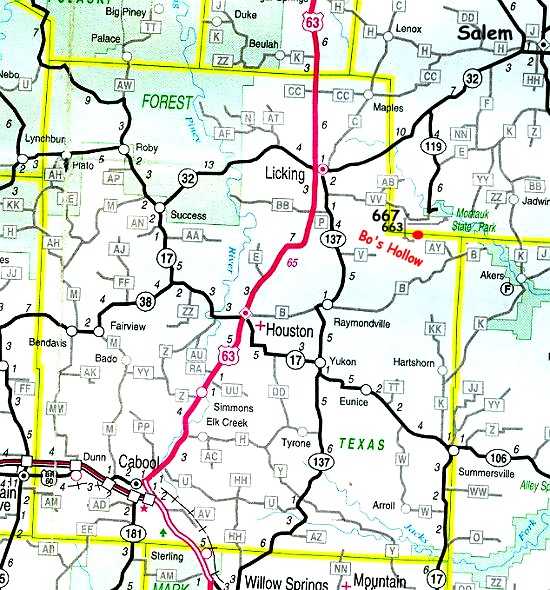
We are located on the Dent - Texas County Line in South Central Missouri. Rolla is 45 miles to our North. We are
140 miles West of Saint Louis, and 115 miles East of Springfield. We are 2 miles South of Montauk State Park. When you
come to Bo's Hollow you don't have to worry about traffic.
GPS: N 37. 25367
W 091. 41039
| This is our general location |

|
| Between Salem,Licking and Houston - 2mi. south of Montauk |
| This might help a little more |

|
| Call 573-548-2429 if you need directions |
Distances
- Licking 12 miles
- Salem 20 miles
- Houston 21
- Raymondville 14 miles
From Rolla go south on Hwy 63, Turn left at traffic light to Licking, go to stop sign, Turn right on Hwy.137,
Turn left on Hwy.VV, You will go about 9 miles on VV, Road will make a sharp left curve, A sign will say Montauk 1 mile, You
will go to your right at the curve onto county road 6630, curve to your right again on to 6633, continue on. You will
cross a low water bridge. Keep going, you are not lost. It's not much further till you see Bo's Hollow.
From Houston at caution light turn onto B Hwy. to Raymondville, curve right around cafe then left on side of City
Hall, still following B Hwy. Go about 12.5 miles, Turn left on AY Hwy. At tee (Ashley Creek Road) turn right. Cross the
low water bridge. Keep going cause you just have a few more feet to Bo's Hollow.
From Salem take Hwy 32 west, Turn left on Hwy.119, Curve to right on VV Hwy. At sharp right curve, turn left
on county road 6630, right onto 6633, Follow this into the valley. Cross over low the water bridge. Just a little farther till
you get to Bo's Hollow.
Just a warning cell phones don't work in the Hollow!
SEE YOU IF THE CREEK DON'T RISE!
|

